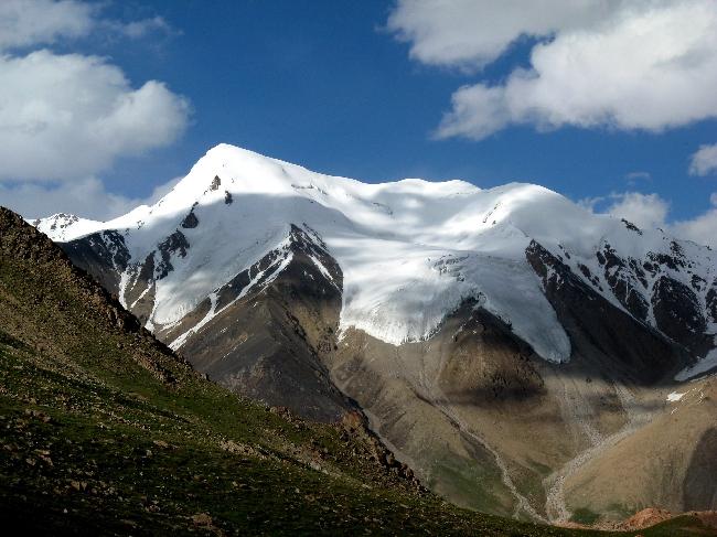
Minglik Sar Peak (6,050m) is a relatively accessible
6,000m snow peak in Pakistan, located in the remote Shimshal Valley of Gojal,
Upper Hunza, Gilgit-Baltistan. Known locally as Minglik Sar, the peak lies near
Shimshal Pass (4,735m) and offers spectacular views of some of the major peaks
of the Karakoram, including Yazghil Sar (6,000m), Lupghar Sar (7,200m), Kunjut
Sar, Distaghil Sar (7,885m), and the Shimshal Whitehorn area.
Minglik Sar is generally regarded as a relatively
non-technical 6,000m peak compared with more demanding Himalayan and Karakoram
climbing objectives. However, an ascent still involves high-altitude
mountaineering, snow and glacier terrain, steep snow slopes, acclimatization
and appropriate technical equipment. It can be a suitable progression objective
for experienced trekkers moving toward their first 6,000m ascent or preparing
for higher peaks such as Spantik and other 7,000m objectives.
Eco Adventurers Tours has organized Minglik Sar expeditions
since 2018 with local Shimshali guides from Shimshal Village. Our local team
has experience on Minglik Sar, Rush Peak, Shimshal Pass, Batura Glacier and
Patundas, providing expedition logistics and local mountain knowledge.
Quick Facts – Minglik Sar Peak
|
Feature |
Details |
|
Peak |
Minglik
Sar Peak |
|
Altitude |
6,050m
(19,849 ft) |
|
Location |
Shimshal
Valley, Gojal, Upper Hunza, Gilgit-Baltistan, Pakistan |
|
Mountain
Range |
Karakoram,
Shimshal region |
|
Difficulty |
Difficult
high-altitude snow climb; relatively non-technical but requiring
mountaineering skills |
|
Best
Time |
July–August;
main climbing season June–September |
|
Starting
Point |
Islamabad |
|
Base |
Shimshal
Village 3,000m, Shimshal Pass 4,735m, Minglik Sar Base Camp approximately
4,800m |
|
Trek
Distance |
Approximately
42–45 km from Shimshal Village to Shimshal Pass/Base Camp, depending on route
and camp locations |
|
Expedition
Duration |
17 Days
Islamabad to Islamabad |
|
Maximum
Altitude |
6,050m |
|
Permits |
Required
trekking/climbing and local area permits, subject to current regulations |
Why Climb Minglik Sar Peak 6,050m?
A relatively accessible 6,000m objective
Minglik Sar is regarded as one of the more accessible 6,000m
snow peaks in Pakistan. Compared with highly technical Himalayan and Karakoram
objectives, the route generally involves snow slopes rather than sustained
vertical technical climbing. Nevertheless, climbers need good fitness,
acclimatization, appropriate equipment and the ability to travel safely on
high-altitude snow and glacier terrain.
A progression peak for higher mountains
Minglik Sar can provide valuable experience for climbers
progressing from high-altitude trekking toward more demanding mountaineering
objectives. Experience gained at altitude can be useful preparation for future
climbs such as Spantik (7,027m) and other high Karakoram peaks.
Remote Shimshal Valley experience
Shimshal Village, at approximately 3,000m, is the gateway to
the expedition. The valley is known for its Wakhi culture, traditional mountain
lifestyle, yak herding and long history of producing experienced high-altitude
mountain guides and porters.
Spectacular Karakoram views
The expedition provides views toward major peaks of the
Shimshal and Karakoram region, including:
- Distaghil
Sar – 7,885m
- Kunjut
Sar
- Lupghar
Sar – 7,200m
- Yazghil
Sar – approximately 6,000m
- Shimshal
Whitehorn
- Other
surrounding Karakoram peaks
Shimshal Pass – 4,735m
The approach to Minglik Sar passes through Shimshal Pass and
traditional high pastures used by local communities. The trekking route passes
through areas including Shuwart, Shujerab and Past Furzeen, where trekkers may
encounter yak and sheep herding.
Experienced local Shimshali guides
Our expeditions use experienced local Shimshali mountain
guides familiar with the Minglik Sar route and surrounding terrain. Their local
knowledge supports route management, logistics, acclimatization and expedition
operations.
Best Time to Climb Minglik Sar Peak
The main climbing season for Minglik Sar is generally June
to September, with July and August normally offering the most favorable
conditions.
July and August generally provide longer daylight hours,
accessible trekking routes and relatively stable summer weather. Conditions at
high altitude can still change rapidly, and summit attempts always depend on
current weather, snow, ice and route conditions.
Typical temperatures can vary significantly between the
valley, Base Camp, High Camp and summit. Trekkers should therefore be prepared
for sub-zero temperatures and strong winds at higher elevations.
June can bring greater snow on higher sections of the route,
while September can become colder and may bring an increased possibility of
early snowfall.
Winter conditions can make the approach and Shimshal Pass
inaccessible and are not suitable for this standard expedition itinerary.
How to Reach Minglik Sar Peak – Shimshal Valley
The expedition starts in Islamabad.
The journey can be completed by road via the Karakoram
Highway or by combining a domestic flight to Gilgit with road transportation,
depending on the expedition schedule, weather and flight availability.
Islamabad → Chilas
The road journey via the Karakoram Highway generally passes
through Abbottabad, Mansehra, Besham and Dasu before reaching Chilas.
When Babusar Pass (4,173m) is officially open and road
conditions permit, the route may instead use Islamabad → Naran → Babusar
Pass → Chilas.
If Babusar Pass is closed, the expedition uses the Karakoram
Highway route.
Chilas → Hunza
From Chilas, the journey continues through Gilgit toward
Hunza and Karimabad, with opportunities to view Rakaposhi and other major
Karakoram peaks.
Hunza → Shimshal Village
From Hunza, the route continues through Passu and along the
Shimshal Road to Shimshal Village by 4x4 vehicle.
The final road section is mountainous and can be rough. Road
conditions can change because of weather, landslides and other local factors.
Shimshal Village, at approximately 3,000m, is the starting
point of the trekking approach.
17-Day Minglik Sar Peak Expedition 6,050m
Day 1: Islamabad Arrival – 500m
Arrival in Islamabad and transfer to the hotel.
Meet the expedition team for a briefing and equipment check.
Complete any required permit and expedition formalities.
Overnight: Islamabad hotel.
Day 2: Islamabad to Chilas – 1,200m
Drive from Islamabad toward Chilas via the Karakoram
Highway, passing through Abbottabad, Mansehra, Besham and Dasu.
The journey follows the Indus River through spectacular
mountain scenery.
If Babusar Pass (4,173m) is officially open and road
conditions permit, the expedition may use the Islamabad–Naran–Babusar–Chilas
route instead.
Driving time: Approximately 12–14 hours depending on
route and road conditions.
Overnight: Chilas hotel.
Day 3: Chilas to Hunza Karimabad – 2,400m
Continue from Chilas toward Gilgit and Hunza.
The journey provides views of the surrounding Karakoram
mountains and may include a stop at a Rakaposhi viewpoint.
Continue to Karimabad, the historic center of Hunza.
Overnight: hotel in Karimabad.
Day 4: Karimabad to Shimshal Village – 3,000m
Travel by 4x4 vehicle from Karimabad through Passu and
onward along the Shimshal Road to Shimshal Village.
Shimshal is the gateway to the Minglik Sar expedition and is
known for its Wakhi culture, traditional mountain lifestyle and experienced
local guides and porters.
Meet the local Shimshali expedition team and prepare for the
trekking approach.
Overnight: Homestay or local accommodation in
Shimshal Village.
Day 5: Shimshal Village to Shuwart Pasture – 3,200m
Begin the trek from Shimshal Village toward Shuwart Pasture.
The trail follows the Shimshal River through mountain
terrain and traditional grazing areas.
Local yaks may be used to transport expedition baggage and
supplies.
Distance: Approximately 12 km
Trekking time: Approximately 5–6 hours
Altitude: Approximately 3,200m
Overnight: Camp at Shuwart.
Day 6: Shuwart to Shujerab – 3,800m
Continue from Shuwart toward Shujerab through the upper
Shimshal Valley.
The route passes through mountain pastures and provides
views toward surrounding peaks including Lupghar Sar.
Distance: Approximately 14 km
Trekking time: Approximately 6–7 hours
Altitude: Approximately 3,800m
Overnight: Camp at Shujerab.
Day 7: Shujerab to Past Furzeen – 4,300m
Trek from Shujerab toward Past Furzeen.
The trail enters higher mountain pasture terrain, with views
toward Yazghil Sar and the Shimshal Whitehorn area.
The gradual altitude gain provides an important opportunity
for acclimatization before reaching Base Camp.
Distance: Approximately 10 km
Trekking time: Approximately 5–6 hours
Altitude: Approximately 4,300m
Overnight: Camp at Past Furzeen.
Day 8: Past Furzeen to Shimshal Pass 4,735m and Minglik
Sar Base Camp – approximately 4,800m
Continue from Past Furzeen toward Shimshal Pass.
Reach Shimshal Pass at approximately 4,735m, an
important high-altitude point on the approach to Minglik Sar.
Continue toward Minglik Sar Base Camp at approximately
4,800m.
Distance: Approximately 6–7 km
Trekking time: Approximately 4–5 hours
Altitude: Approximately 4,800m
Overnight: Minglik Sar Base Camp.
Day 9: Acclimatization Day at Base Camp – approximately
4,800m
Spend the day acclimatizing at Base Camp.
Depending on conditions, the team may undertake a short
acclimatization hike toward approximately 5,000m before returning to camp.
Use the day for:
- Rest
and hydration
- Crampon
practice
- Rope
and harness practice
- Equipment
checks
- Route
briefing
- Weather
assessment
The expedition leader and mountain team monitor conditions
before the summit attempt.
Overnight: Base Camp.
Day 10: Base Camp to High Camp – approximately 5,300m
Climb from Minglik Sar Base Camp toward High Camp.
The route involves steeper snow terrain and may include
glacier or crevassed sections depending on current conditions. Appropriate
technical equipment and rope procedures are used according to the route and
mountain conditions.
Altitude gain: Approximately 500m
Trekking/climbing time: Approximately 4–5 hours
Reach High Camp and prepare for the early-morning summit
attempt.
Overnight: High Camp at approximately 5,300m.
Day 11: Summit Day – High Camp to Minglik Sar Summit
6,050m and Return to Base Camp
Begin the summit attempt with an early alpine start, subject
to weather and route conditions.
Climb from High Camp at approximately 5,300m toward the Minglik
Sar summit at 6,050m.
The upper route includes steep snow terrain and a final
summit section. Depending on current conditions, crampons, harnesses, ropes,
ice axe and other mountaineering equipment may be required.
After reaching the summit, descend carefully to High Camp
and continue toward Base Camp.
Elevation gain to summit: Approximately 750m
Summit-day duration: Approximately 12–15 hours, depending on weather,
snow conditions, route conditions and individual pace.
The summit attempt is not guaranteed. The expedition leader
may delay, shorten or cancel the summit attempt if weather, snow, ice, route or
safety conditions are considered unsuitable.
Overnight: Base Camp, if conditions and timing
permit.
Day 12: Reserve Day for Summit – Weather Contingency
A dedicated reserve day is kept for the summit attempt in
case Day 11 is affected by weather or mountain conditions.
If the summit is successfully completed on Day 11, this day
can be used for rest and recovery at Base Camp.
Overnight: Base Camp.
Day 13: Minglik Sar Base Camp to Shujerab – 3,800m
Begin the return trek from Base Camp.
Descend through Past Furzeen toward Shujerab.
The descent allows the team to return gradually to lower
elevations following the summit attempt.
Overnight: Camp at Shujerab.
Day 14: Shujerab to Shimshal Village – 3,000m
Continue the descent through Shuwart toward Shimshal
Village.
On arrival, celebrate the completion of the expedition with
the local Shimshali team.
Depending on availability, guests can experience local
dishes such as chapshuro, mamtu and butter tea.
Overnight: Homestay or local accommodation in
Shimshal Village.
Day 15: Shimshal Village to Hunza Karimabad and Gilgit
Travel by 4x4 vehicle from Shimshal Village through Passu
and Hunza toward Gilgit.
The journey provides another opportunity to enjoy the
Karakoram landscape after completing the expedition.
Driving time: Approximately 7–8 hours depending on
road conditions.
Overnight: Gilgit hotel.
Day 16: Gilgit to Islamabad – Flight or Road
Return from Gilgit to Islamabad.
The preferred option is a domestic flight, subject to
weather and airline operations.
If the flight is cancelled or unavailable, the return
journey can be made by road via Chilas and the Karakoram Highway.
This day is intentionally kept flexible because mountain
weather can affect Gilgit flights.
Overnight: Islamabad if required.
Day 17: Islamabad Departure
Transfer to Islamabad International Airport for departure.
Expedition debrief and completion of the Minglik Sar Peak
Expedition.
End of expedition.
Best Time, Fitness & Packing List
Best Time
Main season: June–September
Recommended period: July–August
July and August generally provide the most favorable
conditions for the Shimshal approach and Minglik Sar summit attempt, but
mountain conditions can vary significantly from year to year.
Fitness Requirements
Minglik Sar requires good physical fitness and preparation
for prolonged activity at high altitude.
Participants should be capable of:
- Trekking
for approximately 6–8 hours on consecutive days
- Hiking
at elevations above 4,000m
- Carrying
a personal daypack
- Managing
long summit days
- Climbing
approximately 750m from High Camp toward the summit
- Operating
comfortably in cold, windy and high-altitude conditions
Previous experience above 4,000m is strongly recommended.
Previous experience on a 5,000m peak such as Rush Peak can be useful but is not
mandatory for appropriately prepared climbers.
Training should ideally begin several months before the
expedition and include hiking, stair climbing, running and strength/endurance
training.
Packing List
Participants should prepare appropriate high-altitude
mountaineering equipment, including:
- Mountaineering
boots suitable for snow and ice
- Crampons
- Harness
- Helmet
- Ice
axe
- Warm
down jacket
- Insulated
layers
- Waterproof
shell
- Warm
gloves
- Goggles
- Headlamp
with spare batteries
- 50–60L
backpack
- Appropriate
sleeping bag for expected temperatures
- Water
bottles or hydration system
- Trekking
poles
- Sunglasses
- Sunscreen
SPF 50+
- Personal
first-aid and medication supplies
- Personal
toiletries
Frequently Asked Questions
What is the height of Minglik Sar Peak?
Minglik Sar Peak is approximately 6,050m (19,849 ft)
high and is located in the Shimshal Valley of Gojal, Upper Hunza, near Shimshal
Pass.
Is Minglik Sar difficult?
Minglik Sar is generally considered a relatively accessible
6,000m snow peak compared with more technical high-altitude climbing
objectives. However, it is still a difficult high-altitude mountaineering
expedition requiring good fitness, acclimatization, appropriate technical
equipment and experience in mountain environments.
The route may involve snow slopes, glacier or crevassed
terrain and a long summit day. Previous high-altitude trekking experience is
strongly recommended.
Is Minglik Sar suitable for beginners?
Minglik Sar should not be treated as a beginner trekking
peak simply because it is relatively non-technical.
It can be suitable as a progression objective for
experienced high-altitude trekkers who are properly prepared for a 6,000m
ascent. Participants should ideally have previous experience trekking above
4,000m and be comfortable with long mountain days.
Do I need previous mountaineering experience?
Previous mountaineering experience is strongly recommended.
Participants should understand high-altitude risks and be prepared to use
equipment such as crampons, harnesses and an ice axe where required.
Technical equipment and procedures are explained and
practiced during the expedition according to the route and current conditions.
What is the best time to climb Minglik Sar?
The main climbing season is June to September, with July
and August generally considered the preferred period because of the summer
weather and accessibility of the Shimshal approach.
Mountain conditions remain variable, and the final summit
attempt always depends on current weather, snow, ice and route conditions.
How many days does the Minglik Sar expedition take?
The standard itinerary is 17 days from Islamabad to
Islamabad.
The itinerary includes the journey to Shimshal, four days of
trekking toward Base Camp, an acclimatization day, High Camp, a summit attempt,
a reserve weather day and the return journey through Hunza and Gilgit.
What happens if the weather prevents the summit attempt?
A dedicated reserve day is included in the itinerary for
weather or route delays.
If conditions remain unsuitable, the expedition leader may
postpone, shorten or cancel the summit attempt based on safety considerations.
A summit cannot be guaranteed because mountain weather and
route conditions can change rapidly.
Can foreigners climb Minglik Sar Peak?
Foreign visitors can undertake Minglik Sar expeditions
subject to applicable Pakistani permits, regulations and entry requirements.
Eco Adventurers Tours can arrange expedition logistics
including local Shimshali guides, transportation, permits included in the
agreed package, porters/yaks, camping and meals.
Foreign participants should also have appropriate travel and
mountaineering insurance covering high-altitude trekking and rescue/evacuation
where required.
Plan Your Minglik Sar Expedition
Planning to climb Minglik Sar at 6,050m?
Eco Adventurers Tours organizes guided Minglik Sar
expeditions from Islamabad through Hunza and Shimshal Valley, combining local
Shimshali mountain expertise with expedition logistics, camping support,
acclimatization planning and high-altitude mountain support.
View the Minglik Sar Expedition 6,050m
Contact Eco Adventurers Tours
Start your journey from Islamabad and experience one of the
most spectacular high-altitude expeditions in the Shimshal Valley and
Karakoram.